Description
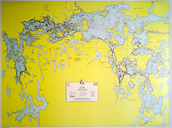
Size 22-3/8″ x 34″, Scale 1″ = 1 mile, Waterproof*
A depth map of Lac La Croix based on soundings taken by the state in 1976. Lake bottom contours are shown in 10-foot intervals in both U.S. and Canadian waters. Bold lake names shown not actually printed on map.

Reviews
There are no reviews yet.